Recent History Over the past few months I’ve made a couple of terrain models in ArchiCAD 14 and then exported them to SketchUp 8. At first this was done to figure out a way to collaborate with a fellow architect who is an avid SketchUp user. We both wanted to work in the program we knew best. After I modeled the first site it became evident that it was incredibly faster, more accurate, easier, and all around better to model the existing site in ArchiCAD rather than in SketchUp. Since then I’ve whipped up a few more sites in ArchiCAD to save time for the SketchUp users. Yes that’s right. I now model things in ArchiCAD for others to use in SketchUp because it is FASTER than my coworkers doing the work in SketchUp.
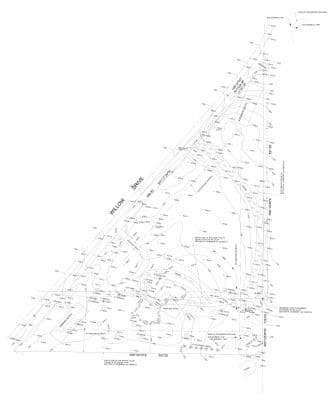
Challenge Accepted The first site we actually modeled head to head. I had been asked to model a site in ArchiCAD 14 and see how the export process worked. But I was busy with other work and hadn’t gotten to it. One day I saw my coworker starting to model the site in SketchUp 8 and thought “Crap. I can’t let him do that. That’s supposed to be my job!” I quickly dropped everything I was doing and prepared to build the site model in ArchiCAD. I opened up the .dwg survey we had, built a mesh and had it cleaned up in SketchUp before my coworker had even prepared the .dwg in SketchUp to a point where he was ready to model in 3D. My model looked great in both ArchiCAD and SketchUp. But my coworker decided it would be better to have the site modeled as stepped contours instead of a mesh surface. So I rebuilt the site out of slabs and was still done before a single 3D element was made in SketchUp.
Here’s the process and some more images:
Step 1 Drag and drop a .dwg from the surveyor into ArchiCAD. This is the easiest way to handle xref’s in ArchiCAD 14 and newer. It’s super slick, and deserves a blog post unto itself (like many other things mentioned in this experiment).
Step 2 Model the site in ArchiCAD (mesh or slabs), using the .dwg as an underlay. I typically put the .dwg on story -3 (below my lowest used story) and trace reference it in so that it doesn’t get in the way. I never use the actual lines from the survey because they rarely connect and everything can be simplified. Lines need to connect because site building involves a lot of magic wand usage (space+click). I also don’t use curved lines in my mesh contours or in my slabs. Curves are not necessary in meshes. When the mesh is set to smooth, you can’t tell the difference between a curved line with 40 nodes and 4 straight lines. Fewer nodes = fewer faces = less demanding on your computer. Same goes for sites built out of slabs. Your site model is already an abstraction based on an abstraction (the survey), so make your life simple and don’t be a slave to the surveyor’s goofy lines. Further more a simplified mesh or series of slabs is easier to modify later.
Step 3 Save the model as a .3ds file from the 3D window. Set drawing unit to 1.00 inches.
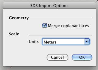
Step 4Â Open SketchUp 8, cry a little bit, go to FILE/IMPORT, select 3DS FILES (*.3ds), click on options, set the Scale in the 3DS Import Options in SketchUp so that Units are meters, pick your file and import.
|
|
The units part makes sense, right? Not to me. How did I figure this units weirdness out? I made a 10′ x 10′ x 10′ cube in ArchiCAD and continued to export it and import it with different settings until it measured correctly in SketchUp. Trial and Error… part of my problem solving arsenal. Okay, I realize most of my readers use the metric system and not imperial. Anyone know what the screwy export requirements are for meters in ArchiCAD to meters in SketchUp? Somehow I doubt it’s as nonsensical as inches to inches. Makes me think of this Youtube video about the pros and cons of metric/imperial (don’t worry it’s short).
Conclusion of sorts So this was all done in ArhiCAD 14 on a Mac. With 15 (and earlier versions on a PC), one can just export directly to .skp via a free plug-in. I’ve played around a bit with that now. There are pros and cons to both methods. The export to .skp comes through much cleaner; no faces missing (which I sometimes noticed with the .3ds file). The export to .skp also retains layers. Which is awesome for exporting buildings. But I found with the stepped site model, the .3ds file was easier to break apart and clean up. This is probably more a reflection of my (happy) ignorance of SketchUp best practices than the actual advantages of exporting via .3ds or .skp. Anyways, I’m working on a new project with the coworker I mentioned at the beginning of this post. He’s once again using SketchUp 8. I’m now using ArchiCAD 15. Lots more to share. Let’s just say the theme of some future posts will be “Anything you can do, I can do better” and “Okay, I’ll steal that; what else you got?”
Your turn I know I left out a lot of little details, so please comment with your questions.
Your turn again Also, who else has experience with the connection between ArchiCAD and SketchUp? I’d love to hear your stories.
Want MORE? Check out this post on stealing materials from SketchUp and bringing them to ArchiCAD.
Did you Enjoy this Post? Follow Shoegnome on Facebook, Twitter, and Youtube for more!


